Edinburgh Nature Network (ENN) is a long-term strategic approach to manage, restore and enhance the urban landscape of Edinburgh. It highlights opportunities to take action across the city, using natural solutions to address the threats of biodiversity loss and climate change.  

It focuses on creating a well-connected, healthy, resilient ecosystem whilst enhancing the ability of the city to adapt to climate change, providing multiple benefits to wildlife, human society and the economy.

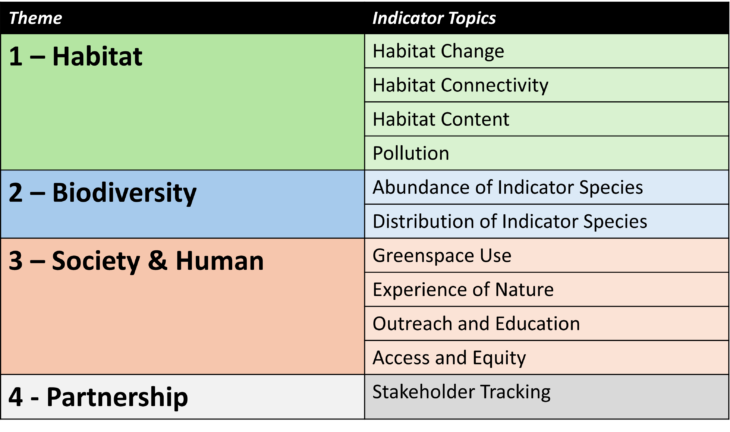
Edinburgh Nature Network Maps 

Below is a map consisting of the major components of the Edinburgh Nature Network. Please click on each symbol for more information, and use the toggles in the legend on the left to view/hide the following map layers: 

  • ENN Actions – Type View – These are the opportunities for nature, identified through the development of the Edinburgh Nature Network, which have the greatest potential for impact across the city, and are categorised by their action type; either ‘Connect,’ ‘Create,’ ‘Enhance,’ ‘Restore,’ or ‘Protect.’
  • ENN Actions – Status View – These are the opportunities as above, but categorised by their progress; either ‘Complete,’ ‘In Progress,’ or ‘Remaining Opportunity.’ This is informed by responses from the ENN survey and knowledge of the actions by the ENN team.
  • ENN Action Log – Delivery – These are the sites of project delivery which have been entered to our ENN data survey by organisations delivering actions for nature across Edinburgh. Click on the ‘Maximize’ button in the top-right corner of the pop-up for full information of this intervention.

Key contacts

Scottish Wildlife Trust
City of Edinburgh Council

Related category

If you wish to view the Edinburgh Nature Network Actions in PDF form, they have been categorised and can be found in the corresponding drop-downs below:

There are 41 incredible opportunities to improve aquatic and marine habitats in Edinburgh that were identified through the ENN, whether relating to the Firth of Forth or inland rivers and burns. Please find the category file below:

Marine and Aquatic ENN Category File

There are 58 incredible opportunities to improve grassland in Edinburgh that were identified through the ENN, and to create biodiversity-friendly wildflower meadows. Please find the category file below:

Grassland and Wildflower Meadow ENN Category File

There are nearly 50 incredible opportunities to improve native woodland and hedgerow habitats in Edinburgh that were identified through the ENN. Please find the category file below:

Native Trees and Hedgerows ENN Category File

There are nearly 50 incredible opportunities to improve wetland and wet woodland habitats in Edinburgh that were identified through the ENN. Please find the category file below:

Wetland ENN Category File

There are 8 great opportunities to improve peatland, heathland and bog habitats within the Edinburgh region that were identified through the ENN. Please find the category file below:

Heathland and Peatland ENN Category File

There are 24 incredible opportunities to green the built environment in Edinburgh that were identified through the ENN which would provide benefits to both people and nature. Please find the category file below:

Built Environment ENN Category File

There are 12 great opportunities to improve the potential of Edinburgh’s streets in nature restoration actions that were identified through the ENN. Please find the category file below:

Street Greening ENN Category File

There are over 75 incredible opportunities which focus on actions for specific species and taxonomic groups in Edinburgh that were identified through the ENN. Please find the category file below:

Species Specific ENN Category File

There are 31 incredible opportunities to enhance the wellbeing of the local population by improving their access to nature that were identified through the ENN. Please find the category file below:

Human Access ENN Category File

Monitoring & Evaluation 

To assess the progress and impact of the Edinburgh Nature Network, the Scottish Wildlife Trust have developed a Monitoring & Evaluation Framework. By combining data that is already being measured with primary data collection on actions for nature across the city, the Edinburgh Nature Network can be assessed against its core themes of: 

  • Habitat 
  • Biodiversity 
  • Society 
  • Partnership & Collaboration

Survey123 is a spatial mapping tool which is part of the GIS suite. One of these surveys has been created to track project delivery across the city. This will increase the general understanding of Edinburgh’s nature projects, encourage a collaborative approach to biodiversity management, and enable us to cross-reference the responses with Edinburgh Nature Network actions to evaluate the overall progress of the ENN.


Responses to the survey are being submitted by a number of different organisations working on actions for nature across Edinburgh.

If you wish to log your actions, the link to the survey is displayed here:

Further to this, data is being collated regularly to assess wider, landscape-scale impacts of the Edinburgh Nature Network, most notably on biodiversity. An increase in biodiversity is a core aim of the Edinburgh Nature Network, and by tapping into existing species monitoring data, for example pollinator transects or the BTO’s Breeding Bird Survey, trends can be assessed and observed. Citizen science is a key aspect of this part of the project.

The Monitoring and Evaluation Framework was developed after a series of consultation workshops with representatives from 18 different stakeholder organisations.

Development Background 

Nature Networks are a requirement within every local authority in Scotland. Edinburgh’s Nature Network was the first and was developed in partnership between the City of Edinburgh Council and the Scottish Wildlife Trust, as part of the Thriving Green Spaces project.

The Nature Network was created by applying the environmental decision-making process outlined in the Ecological Coherence Protocol and adapting it to the urban environment. We brought together a range of experts and city residents to create a unique, fully-integrated urban map of habitats and the ecosystem services being provided by outdoor spaces in the city. By combining geographical data with local knowledge and practical considerations, we identified opportunities for nature-based solutions and environmental enhancements that provide multiple benefits for both people and wildlife.

In doing so, we created a powerful tool that provides a strategic approach to prioritise environmental enhancements and nature-based solutions to tackle the threats of climate change and biodiversity loss.

It highlights areas of the city with the highest demand for changes like planting trees, which provide the oxygen we breathe, or creating areas of wetland to hold water and reduce flooding. Both of these will also have a cooling effect on the city, helping us to adapt to future increases in temperature due to climate change.

To view the ENN StoryMap, which was created during the ENN’s development, click here.

Project partners

Latest

Improving the Mound for nature

Exciting work is taking place to improve the Mound for nature. Cheryl Jones, Sustainability Manager, Future Workplace, Lloyds Banking Group explains how the company is improving the greenspace around its iconic

[fts_mashup posts=1 social_network_posts=2 words=45 center_container=yes show_social_icon=left facebook_name=EdinburghLivingLandscape twitter_name=EdinLandscape]