A Guide to Developing and Monitoring a Nature Network
,
It is now an obligation for all local authorities in Scotland to develop a nature network. This is a simple and generic 15-step guide to creating a nature network and assessing its progress against the core aims of improving nature connectivity, biodiversity and the relationship between people and nature. This document was developed using the Edinburgh Nature Network as a guide, which was Scotland’s first nature network.
Download the guide here: How to develop a nature network
Presented below is a project timeline for creating and monitoring a nature network. Consider it a roadmap to the successful delivery and monitoring/evaluation of a nature network.
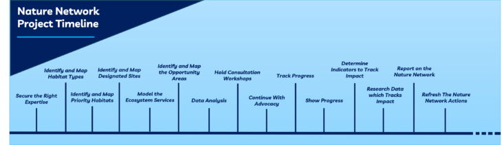
1. Secure the Right Expertise
It is crucial to have Geographical Information System (GIS) mapping specialists and ecologists involved in this project from the outset, as well as community engagement experts. People who can identify opportunities for changing how land is managed must be involved too, whilst also considering specific types of expertise needed for the area, such as woodland, grassland or wetland experts.
2. Identify and Map Habitat Types
To create nature network maps, several different map layers need to be assembled. Using a general map of the geographical area as a base, other detailed layers can be added using habitat classification data that is detailed enough to allow the identification of priority habitats (see step 3).
These datasets may not necessarily include the type of green space found in urban areas. Therefore, an important extra step is to add an urban habitat layer with elements such as private and public gardens, cemeteries and churchyards, parks, playing fields, green corridors, and allotments. Some of this data is available on Ordnance Survey Open Greenspace.
3. Identify and Map Priority Habitats
This should include priority habitats which are considered to be at greatest risk of being lost or threatened and require conservation. These can be found on the UK BAP priority list (Biodiversity Action Plan) or the equivalent in the area of the nature network.
4. Identify and Map Designated Sites
This should include sites with statutory protections such as: Sites of Special Scientific Interest (SSSI), Special Protection Areas (SPA), Special Areas of Conservation (SAC), Marine Protected Areas (MPA) and Ramsar areas (wetlands of international importance). Additionally, identify any locally designated sites, such as nature reserves and local biodiversity sites, as these are just as important to a local context.
5. Model the Ecosystem Services
Ecosystem services are the benefits to people from habitats and wildlife. There are seven key ecosystem services specific to biodiversity, they are: air purification, noise regulation, temperature regulation, water purification, flood regulation, health and wellbeing, and insect pollination. Understanding the impacts changes to nature can have on these in the area is vital in assessing the impact of the nature network and in examining the relationship between people and nature.
6. Data Analysis
Using GIS analysis, combine all the data collected in stages 2-5 as layers on a map of your nature network area. This will then help with exploring the connections between the data in the different layers and start to identify key opportunities for interventions or actions.
7. Identify and Map the Opportunity Areas
Opportunity areas are places where there is a real likelihood that positive changes to habitat can reasonably occur. Mapping this aspect requires the drawing together of other relevant information (such as local authority information about open spaces, future housing, and derelict land), as well as the identification of landowners and managers who are keen to support the plan and allow their land to be used as part of a nature network.
It is also important to consider where it is physically possible to make interventions. For example, a block of flats may not present an obvious initial opportunity, but opportunities may arise on its surrounding gardens and roof.
8. Hold Consultation Workshops
Organise engagement sessions with local partners such as ecologists, local government and community representatives, landowners, ENGOs, and other experts, to share the mapping work to date, test and enhance it, and gather suggestions on the most effective and feasible interventions or actions to create or enhance the nature network. These will make up the finalised opportunity map for the nature network.
9. Continue With Advocacy
Continue to advocate for the delivery of the actions created in the opportunity maps. Nature network actions can be delivered by any organisation working in project delivery in the local area, so ensure that all partners in delivery are aware of these actions and are encouraged to deliver them. Creating user-friendly documents of actions categorised by their habitat is a simple way of making the actions easier to interpret and more likely to be used.
Also, deliver the nature network actions. For those who are in a position to complete any of the identified actions, now is the time to create a viable delivery plan. The nature network will show no progress without the delivery of actions.
10. Track Progress
It is important to understand how many nature network actions have been delivered, as it will help inform when to refresh these actions and strive for new goals to improve nature and biodiversity. It is also always good to keep things fresh and continue to adapt, as this will help to encourage positive change.
Create a map which depicts the nature network actions that have been delivered or are in delivery. This could be through a spatial mapping tool such as ArcGIS Online’s Survey123, and by encouraging partners in delivery to engage with this, a map of projects which benefit nature for your area will be created.
11. Show Progress
Ensure that this map of delivery is placed in the public domain, as this can result in additional opportunities, for example around knowledge sharing, project collaboration, and identifying locational gaps in the delivery of the nature network.
Create an additional field in your original mapped actions which categorises these by their status, for example, whether the actions are completed, in progress, or remain as an opportunity, and showcase this too. This will show how many/few actions there are left to either deliver or advocate for their delivery, which can help in prioritising actions further.
12. Determine Indicators to Track Impact
Tracking the progress of a nature network is an important part of monitoring and evaluation, as is ensuring that all activity has actually been contributing to its core aims and objectives. A priority would be to determine the metrics by which to assess impact. Generally, these will cover the key themes of people, e.g. wellbeing and access to nature, habitat, e.g. hectares of woodland created or enhanced, and biodiversity.
For biodiversity metrics, indicator species for the nature network must be identified. Many of the actions will mention beneficiary species for that specific action, whether directly or indirectly, for example a wildflower meadow will benefit pollinators. These species will be the indicator species. As this is an ecological connectivity project, it is very important to track the distribution of these indicator species around network area as well as their abundance.
13. Research Data which Tracks Impact
Conduct desk-based research into existing monitoring activities on the biodiversity, habitat, and societal metrics, as there is often great citizen science already ongoing which can assist with this. This could include biodiversity transects, community watches, or published reports. It may be necessary to contact specific organisations at this stage to access their data, and this is great as it will engage more people in the nature network. Ensure all activity is compliant with GDPR when using external data. If relevant data does not already exist, consider setting-up and facilitating new citizen science monitoring activities.
14. Report on the Nature Network
Ensure that the impacts of the nature network are shown off and publicised. It may encourage others to get involved in projects and actions to further enhance nature, particularly as people often want to feel a part of a wider network of positive activity. Compile a comprehensive report which shows action tracking and all impacts previously discussed, to ensure that every base has been covered. This may also help to show that the nature network created is well thought out ahead of any additional statutory reporting. Also, create a smaller summary report to outline the key statistics and outcomes to a wider audience.
15. Refresh the Nature Network Actions
When the majority of nature network actions are in delivery, or have been delivered, it is time to refresh these actions. It is important to keep the process fresh so actions for nature in the local nature network area do not become stagnant and repetitive. At this stage, innovation and ambition are encouraged to make a greater positive impact on biodiversity.
________________________________________________________________________________
Leo Charlesworth, Edinburgh Nature Network Manager